


Col de la Chambotte

PhilippeC54
User
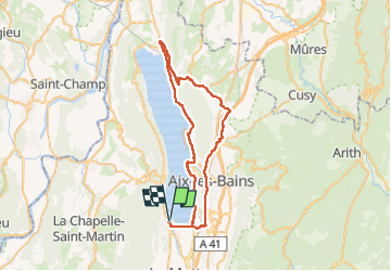

Length
55 km

Max alt
724 m

Uphill gradient
1026 m
Km-Effort
69 km

Min alt
228 m

Downhill gradient
1025 m
Boucle
Yes
Creation date :
2022-06-04 07:53:59.286
Updated on :
2022-06-04 10:59:27.683
2h49
Difficulty : Difficult

FREE GPS app for hiking
 SityTrail
IGN / Geographical institutes
SityTrail Plus
The world is yours!
About
Trail Road bike of 55 km to be discovered at Auvergne-Rhône-Alpes, Savoy, Le Bourget-du-Lac. This trail is proposed by PhilippeC54.
Positioning
Country:
France
Region :
Auvergne-Rhône-Alpes
Department/Province :
Savoy
Municipality :
Le Bourget-du-Lac
Location:
Unknown
Start:(Dec)
Start:(UTM)
723052 ; 5059464 (31T) N.
Comments